| |
Administrative Land Divisions - Districts of Newfoundland and Labrador
Historical documents reveal that most early Newfoundland government officials came from countries whose administrative land divisions were sometimes quite complex and confusing. To their credit, leaving behind them the profusion of counties, shires, baronies, townlands etc. of their homelands, these officials developed a system of administrative land division that was kept fairly simple and straightforward. In Newfoundland, for more than two hundred years, the "district", a term referring to a specific grouping of settlements, has been used as the primary administrative land division.
Before the introduction of a defined "district" system, the location of a settlement in Newfoundland was usually indicated by referring to its presence within the headlands of a specific bay or, failing the existence of that geographic feature, its name was appended with a distinguishing prefix or suffix. Take for example, the two Newfoundland settlements named Brigus. Records show that early official references to the settlement located along the Southern Shore (not within a bay) was often recorded as Brigus by South or Brigus South. The other like-named settlement, in Conception Bay, was quite often just referred to as Brigus or officially, Brigus, Conception Bay. However, as the "district" divisions evolved, Brigus by South, tended to be recorded as "Brigus, Ferryland District" while the Conception Bay settlement stayed basically the same, but for official records, it was usually recorded as "Brigus, Conception Bay District". This district system is still in place today, although some old districts have been renamed, expanded, or subdivided over the years. In addition, new districts were created as the population grew and new settlement areas evolved. The current system is administered by the provincial Government of Newfoundland and Labrador as part of its electoral structure.
The English Shore
Although it is not clear when the district system officially came into being, there are records from the 1780s that use that term in reference to certain areas. It appears that the earliest documented district boundaries were drawn up in preparation for the first general election for Newfoundland, which was held in November 1832. At that time, the English colony of Newfoundland was still divided into two coastal regions referred to, in general terms, as the English and French Treaty Shores. The long disputed French Shore, whose boundaries were created under treaty in 1713 but redefined by another treaty in 1783, was not included in this election. "Officially" no permanent French settlement was allowed and British settlement in that area was considered negligible. In fact, only nine electoral districts were defined for the initial election, all within the English Shore territory. The boundaries of these districts were delineated by specific settlements and/or landmarks along the coastline. No provision was made to include sparsely populated areas along the English and French Shores, or any of Labrador. Labrador actually did not get political representation until after confederation with Canada in 1949.
According to the Journals of the Newfoundland House of Assembly, in the election of 1832, nine districts along the English Shore, with fifteen elected members, were defined as follows:
- St. John's (3 members) - included the areas from Petty Harbour to Broad Cove (later known as St. Phillips). This area also took in Bell Island.
- Conception Bay (4 members) - extended from Broad Cove (St. Phillips) to Bay de Verds (Verde) Head.
- Trinity Bay (1 member) - extended from Bay de Verds (Verde) Head to Cape Bonavista. This area also included Random Island.
- Bonavista Bay (1 member) - extended from Cape Bonavista to Cape Freels.
- Fogo (1 member) - included the islands of Twillingate and Fogo and extended from Fogo Island to Cape St. John. [1]
- Ferryland (1 member) - extended from Petty Harbour to Cape Race.
- Placentia and St. Mary's (2 members) - extended from Cape Race to Rushuen (Rushoon).
- Burin (1 member) - extended from Rushuen (Rushoon) to Garnish.
- Fortune Bay (1 member) - extended from Garnish to Bonne Bay (later known as McCallum). [2]
The French Shore [3]
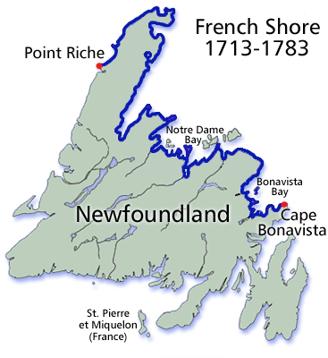
| History records that English-French wars were on again, off again, sporadically from 1689 to 1815. Near the end of one of those wars, The War of The Spanish Succession, the French Treaty Shore of Newfoundland came into existence with the signing of the Treaty of Utrecht in 1713. It provided that the French could fish, in season, on the Newfoundland coast between Cape Bonavista and Point Riche (on the western side of the northern peninsula). This was the area that had been traditionally frequented by French fishermen from Brittany since the early 16th century. Later in the century, with the outbreak of the Seven Years War (1756 - 1763), the French deserted the fishery in this area. However, after the signing of the Treaty of Paris (1763), French fishermen began returning to this area, expecting to reclaim the fishing rights they had abandoned during the war. However, upon their return they discovered, during their absence, British fishermen had arrived there with their families and were now settled in significant numbers, particularly in the northeastern part of their old territory (that the French called "le petit nord") i.e. between Cape St. John and Cape Bonavista. |
 |
| |
Click here to enlarge map |
| | |
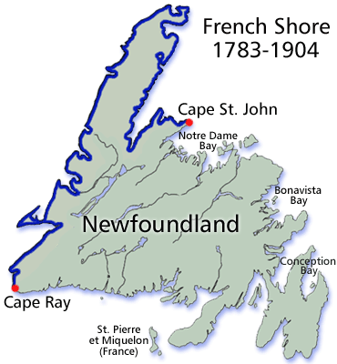
| Although France promptly made protests of this encroachment to England, it was not until the Treaty of Versailles (1783) that a satisfactory agreement was reached. In this treaty, new French Shore boundaries were drawn up officially allowing the British to retain "le petit nord", the decades old disputed territory between Cape Bonavista and Cape St. John on the Baie Verte peninsula. In order to compensate the French for this loss, the treaty extended the original western boundary, at Pointe Riche, all the way south to Cape Ray. Although the French were given concurrent fishing rights in the newly designated area, British subjects were allowed both fishing and settlement rights. Over time the resident British population of the area gradually grew, augmented by some French families, who settled there contrary to the restrictions of the Treaty of Versailles. As the number of subjects inhabiting the French Shore increased, additional districts were added, or boundaries were extended to include these new areas. However, it was not until 1904, with the signing of the Anglo-French Convention, that the land and territorial waters of the French Shore were ceded back to the government of Newfoundland. |
 |
| |
Click here to enlarge map |
Labrador
In 1774, the rugged and sparsely populated area known as Labrador was claimed by Quebec, however, in 1809 the disputed area was transferred back to Newfoundland. Before 1815, Labrador was the permanent home of only a few settlers of European descent, mainly trappers or traders who had married aboriginal wives. Others seasonal settlers, for the most part, were migratory British, or Canadian merchants (based in Qu�bec) who operated seal, cod and salmon stations on the Southern Labrador coast. At the end of the Napoleonic Wars in 1815, the northwest coast of Newfoundland again saw a renewed presence of French fishermen. This French resurgence in that area forced Newfoundlanders, who had fished there during the war, to move further north, into Labrador, in search of new fishing grounds. Of course, they brought with them their families, greatly increasing the permanent Euro-Labradorian population. With the influx of marriageable females, permanent settlement became increasingly more common as migratory fishermen married into the permanent population. Although Labrador gradually grew in population, its population remained relatively small, and it was not included in the Newfoundland electoral process until after our confederation with Canada.
Evolution of districts in Newfoundland and Labrador (1832 - 2011)
The chart below has been designed to show what districts were allocated in our province at various times in our history. It starts with the first election in 1832 and includes several other years when various directories were published, or censuses were taken. It should be kept in mind that many district boundaries have been altered over the years, and researchers may sometimes have to search adjacent districts to locate a town or settlement of interest. The most current map of our provincial districts may be viewed and explored at Newfoundland and Labrador Electoral Districts (courtesy of the Government of Newfoundland and Labrador, Land Branch, Surveys and Mapping Division).
| 1832 [4] |
1871 [5] |
1898 [6] |
1921 [7] |
1935 [8] |
1945 [9] |
2011 [12] |
| Conception Bay |
Harbour Main;
Brigus-Port de Grave;
Harbour Grace;
Carbonear;
Bay-de-Verds |
Harbour Main;
Port-de-Grave;
Harbour Grace;
Carbonear;
Bay-de-Verde |
Harbour Main- Bell Island;
Port-de-Grave;
Harbour Grace;
Carbonear- Bay-de-Verde |
Harbour Main & Bell Island;
Port-de-Grave;
Harbour Grace;
Carbonear & Bay-de-Verde |
Harbour Main & Bell Island;
Port-de-Grave;
Harbour Grace;
Carbonear & Bay-de-Verde |
Harbour Main;
Conception Bay East - Bell Island;
Topsail;
Conception Bay South;
Port-de-Grave;
Carbonear - Harbour Grace |
| St. John's |
St. John's East;
St. John's West |
St. John's East;
St. John's West |
St. John's East;
St. John's West |
St. John's East;
St. John's West |
St. John's East;
St. John's West |
St. John's Centre;
St. John's East;
St. John's West;
St. John's North;
St. John's South;
Signal Hill-Quidi Vidi;
Virginia Waters;
Cape St. Francis;
Kilbride;
Mount Pearl North;
Mount Pearl South |
| Placentia & St. Mary's |
Placentia & St. Mary's |
Placentia & St. Mary's |
Placentia- St. Mary's |
Placentia- St. Mary's;
Placentia West |
Placentia & St. Mary's;
Placentia West |
Placentia - St. Mary's |
| Bonavista (Bay) |
Bonavista (Bay) |
Bonavista |
Bonavista |
Bonavista |
Bonavista North;
Bonavista South |
Bonavista North;
Bonavista South;
Terra Nova |
| Burin |
Burin |
Burin |
Burin |
Burin |
Burin |
Burin - Placentia West;
Grand Bank |
| Ferryland |
Ferryland |
Ferryland |
Ferryland |
Ferryland |
Ferryland |
Ferryland |
| Fogo |
Twillingate & Fogo |
Twillingate;
Fogo |
Twillingate;
Fogo |
Twillingate;
Fogo;
Grand Falls;
Green Bay |
Twillingate;
Fogo;
Grand Falls;
Green Bay |
Baie Verte - Springdale;
Exploits;
Gander;
Lewisporte;
Isles of Notre Dame;
Grand Falls - Windsor/Buchans;
Grand Falls - Windsor/Green Bay South |
| Trinity (Bay) |
Trinity (Bay) |
Trinity |
Trinity |
Trinity North;
Trinity South |
Trinity North;
Trinity South |
Trinity North;
Trinity - Bay De Verde;
Bellvue |
| Fortune Bay |
Fortune Bay |
Fortune Bay |
Fortune- Hermitage |
Fortune, Burgeo & LaPoile |
Fortune & Hermitage |
Fortune Bay - Cape La Hune |
[10]
French
Shore |
Burgeo & LaPoile |
Burgeo & LaPoile |
Burgeo- LaPoile |
Burgeo & LaPoile |
Burgeo- LaPoile |
[10]
French
Shore |
White Bay - 1882 (renamed
St. Barbe
in 1884);
St. George |
St. George's-Port-au-Port;
St. Barbe |
St. George's;
St. Barbe;
Humber;
White Bay |
St. George's & Port-au-Port;
St. Barbe;
Humber;
White Bay |
St. George's - Stephenville East;
Port au Port;
Bay of Islands;
St. Barbe;
Humber East;
Humber Valley;
Humber West;
Straits - White Bay North |
[11]
Labrador |
[11]
Labrador |
[11]
Labrador |
[11]
Labrador |
[11]
Labrador |
[11]
Labrador |
Cartwright- L'anse au Clair;
Labrador West;
Lake Melville;
Torngat Mountains |
Endnotes
[1] Cape St. John, on the northeastern tip of the Baie Verte Peninsula, was the revised northern boundary of the English and French Shore as negotiated in the Treaty of Versailles (1783).
[2] McCallum, on Newfoundland's south coast, formerly called Bonne Bay (not to be confused with Bonne Bay on the west coast) was the south-western most point included in the 1832 election. Although the southern boundary of the English and French Shore was actually further west at Cape Ray, it appears the population was too low to warrant inclusion of this area at that time.
[3] Maps by Tanya Saunders, @2001 Newfoundland and Labrador Heritage Web Site, from article by J.K. Hillier, "The French Treaty Shore" Newfoundland and Labrador Heritage Web Site (@2001) http://www.heritage.nf.ca/exploration/french_shore.html (10 March 2011)
[4] The first election under representative government was held in nine Newfoundland districts defined per Royal Proclamation, dated July 26, 1832. Some Voter's Lists, for this and other early elections, though incomplete, have survived.
[5] Lovell's 1871 Directory and McAlpine's 1870-1871 Directory were published listing male (and some female) heads of households in all Newfoundland districts and the French Shore.
[6] McAlpine's 1898 Business Directory was published listing male and female heads of households in all Newfoundland districts. McAlpine's Newfoundland Gazetteer was also published outlining the location and description of each settlement within the districts.
[7] 1921 Newfoundland Census. Nominal census enumerated on a per district basis.
[8] 1935 Newfoundland Census. Nominal census enumerated on a per district basis.
[9] 1945 Newfoundland Census. Nominal census enumerated on a per district basis.
[10] No representation provided initially, but representation was gradually extended starting in the early 1880s. Although voting rights may not have been extended, heads of resident families were listed in earlier directories/lists, regardless of ethnicity.
[11] As far as I could determine, no representation was provided until after 1949. In the 1911 Canada Census, two subdistricts of Labrador (Northwest River and Rigolet) were enumerated under the Northwest Territories. The entire area under one district - Labrador - was enumerated in the 1935 and 1945 censuses.
[12] There were 48 districts allocated in the province of Newfoundland and Labrador in 2011. The assignment of some districts in this column is approximate, since a number of areas were not populated in earlier times. In addition, various rearrangements of electoral boundaries over the years have resulted in the reallocation of a number of towns and settlements formerly allocated to other districts.
|
|

![[Recent]](../recent.gif)
![[Contacts]](../contacts.gif)
![[Home]](../home.gif)